Built on official MET Norway & Kartverket data

Weather, tides and bite —
all in one place

Plan your next sea-fishing trip in Norway with a 0–10 bite score, tides, wind, waves and currents for your chosen location. No separate app or additional sign-up is required.

0–10
factors in every bite score
7
official Norwegian data APIs
0
sign-ups required
24/7
access to forecasts
Bot and app

What Norway Fishing looks like

A clear interface: bite, map, weather and tides — in the Telegram bot and the app.

Norway Fishing app screenshot: a 7.0 out of 10 bite score for Sturdal, a mini-map and a 24-hour chart

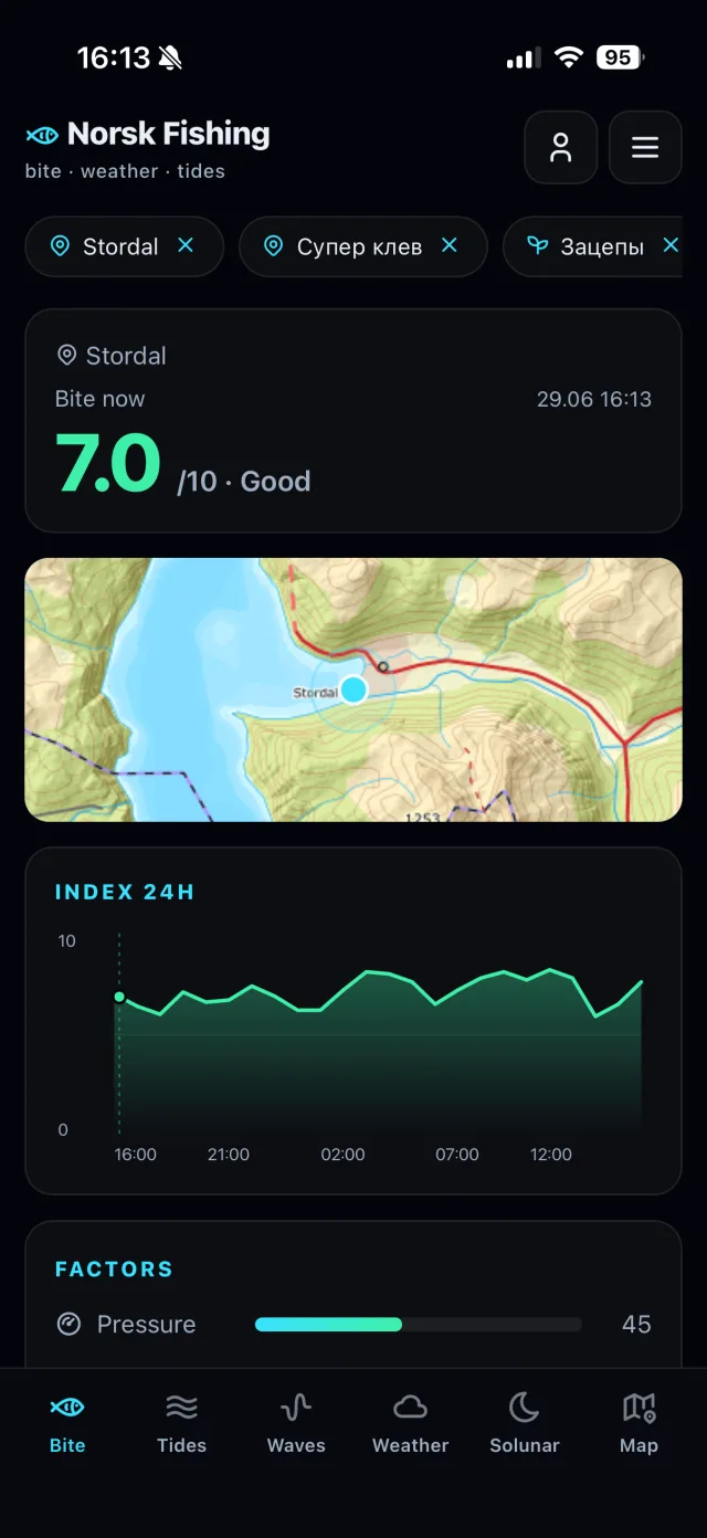
Bite, map and best windows

A 0–10 score, a mini-map of the spot, a 24-hour chart and each factor's contribution.

Norway Fishing app screenshot: a topographic map of Sturdal with saved-spot markers

Map with your spots

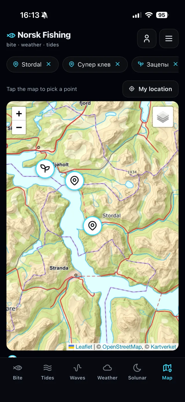
Kartverket topographic and nautical charts, with your saved spots and catches right on the map.

Norway Fishing app screenshot: a temperature chart, wind, pressure, cloud cover and clothing advice

Weather and cloud cover

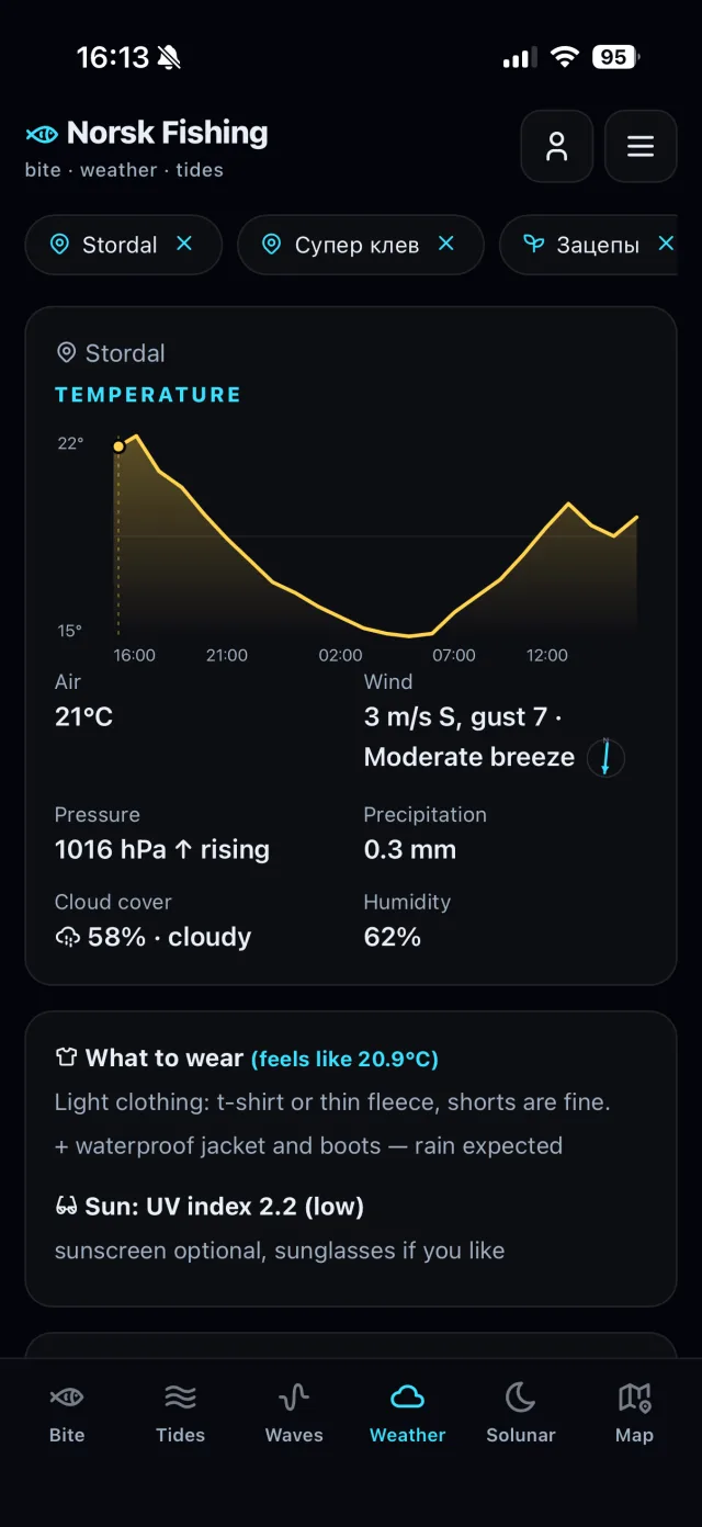
Temperature, wind, pressure, precipitation, cloud cover, UV and what to wear.

Norway Fishing app screenshot: a water-level chart and a list of tides grouped by day

Tides by day

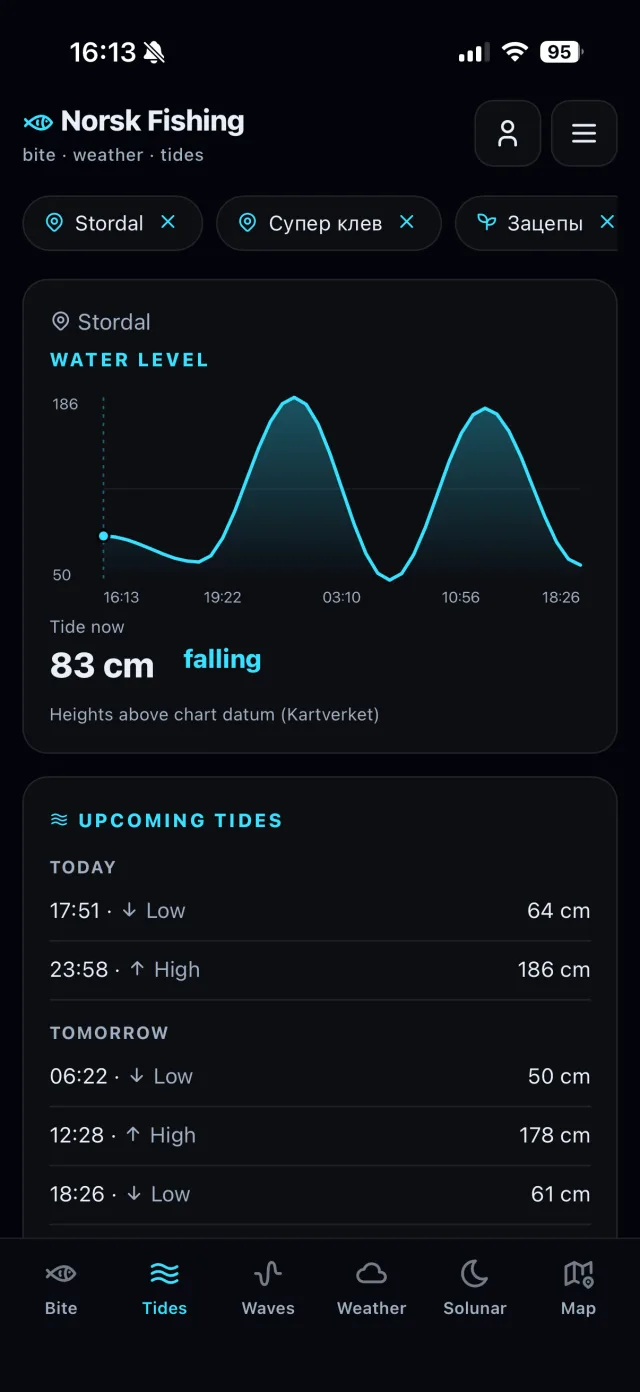
Water level and upcoming high and low tides, grouped by day.

Real app screens, shown with data for Sturdal, Norway.

Features

Your Norway fishing forecast — in one chat and app

Share your location, enter coordinates or choose a preset to get a detailed forecast for your fishing spot.

🎣

0–10 bite score

See the score for the current hour, a factor-by-factor breakdown and the most promising fishing windows over the next 24 hours.

8.4
Pressure
Tide
Light
Moon
🌗

Tides and currents

Official Kartverket data shows the current sea level, whether the tide is rising or falling, the next high and low tides, and peak current — often a productive window for fjord fishing.

Conditions right now

Near-real-time radar and weather data: air temperature, wind and gusts, Beaufort force, pressure trend and precipitation rate.

🌊

Sea and wave conditions

Water temperature, wave height, period and direction, plus current speed from MET Norway's ocean forecast.

👕

Clothing and sun protection

Practical advice based on feels-like temperature, wind chill, cloud cover and UV levels — from waterproof layers to sunglasses.

📅

Multi-day outlook

Temperature, wind, pressure, precipitation and tides in three-hour intervals throughout the day.

Saved spots and morning updates

Save, rename or delete your favourite fishing spots. Get a bite forecast for all of them at 06:00 or 08:00 Norway time.

🗺️

Map and nautical charts

Kartverket topographic and nautical charts with depth soundings. Tap to pick a point, mark places by type and see your catches right on the map.

🐟

Catch log

Log catches with species, size, weight, time and photos. The “Me” section keeps stats, filters and your full history — and helps refine the forecast.

🔄

Optional account

Everything works without registration. With an account, your spots, catches and photos sync across phone, browser and the bot — sign in with Telegram, Google or email.

📍

Four ways to choose a location

Share your location in one tap, choose from eight Norwegian presets (Lofoten, Tromsø, Ålesund, Bergen, Bodø, Hitra, Sørøya and Langesund), enter coordinates or select a saved spot. Sunrise, sunset, moon phase, polar day and polar night are all shown in local time.

How the score works

More than a weather forecast — a model built for fishing

Seven weighted signals combine tide, current, weather, light and lunar conditions in a single score.

🔵
0.24
Pressure + trend
🌗
0.20
Tide (current)
💨
0.16
Wind
🌅
0.12
Light / twilight
🌙
0.12
Moon (solunar)
🌊
0.08
Current speed
☁️
0.08
Cloud cover

The model favours the middle of the tidal cycle, when the water is moving, rather than high or low tide itself. It also uses pressure history from the Frost API, solunar periods based on the Moon's position, dynamic weighting and a safety override for hazardous wind or waves.

Privacy and safety

Minimal data — and full control over what's yours

Registration is optional

The bot and the web version work without registration. To run the chat, the bot receives your Telegram account ID, name and username; it does not ask for your phone number or payment details. You can optionally create an account to sync across devices — it doesn't require a phone number either.

Your spots and catches, your call

Coordinates, saved spots and catch entries are used for the forecast and your own log. They are saved only when you choose to — and you can rename or delete them at any time.

No advertising trackers

Your data is not sold or used for targeted advertising, and the landing page contains no advertising trackers.

Official data sources

Forecasts use data from the official Norwegian services MET Norway and Kartverket, with source attribution and the CC BY 4.0 licence stated clearly.

Only the data the service needs

The service stores only what's needed for spots, the catch log and morning updates. Your email is used to sign in and to reply to messages; photos are stored to show your catches.

No unnecessary permissions

No background permissions: the bot runs in Telegram and the web version in your browser. You add catch photos yourself via a file picker — the app does not scan your gallery.

Account control

Sign in with Telegram, Google or email. You can see active sessions, sign out other devices, download your data or delete your account along with everything in it.

Data sources

Official data, straight from the source

Forecasts are built with data from Norway's meteorological and hydrographic services, available to you free of charge.

MET Locationforecasttemperature, wind and gusts, pressure, precipitation, cloud cover and UV
MET Nowcastnear-real-time radar precipitation, mm/h
MET Oceanforecastwater temperature, waves and currents
MET MetAlertssevere weather warnings
MET Sunrisesunrise, sunset, polar day/night, moon phase and solunar data
MET Frostpressure history from weather stations
Kartverket tideapiofficial tide predictions
Getting started

Your forecast in three steps

01

Open the bot in Telegram

If you already use Telegram, there is no separate app to install or new account to create. Tap Start to begin.

02

Choose a fishing spot

Share your location, choose a preset or enter coordinates. Save the spot if you want to use it again.

03

Check the forecast

See the 0–10 bite score, best fishing windows, tides and weather. Enable morning updates to receive the forecast automatically.

Coordinates

How to find and send coordinates

In the app it's easiest: open the Map tab and tap the spot — no coordinates needed. For the Telegram bot, use this method: pick the spot on a map, copy its latitude and longitude, and send both numbers in one line.

Format accepted by the bot
62.907721735173475, 6.9154728817510485

Latitude comes first, followed by longitude. Use a decimal point inside each number and a comma between the two numbers.

🖥️

Google Maps on a computer

  1. Open Google Maps in your browser and find your fishing spot.
  2. Right-click the exact point on the map.
  3. The coordinates appear at the top of the menu. Click them to copy both numbers.
  4. Paste the line into your chat with the bot and send it.
📱

Google Maps on iPhone or Android

  1. Open the Google Maps app and find the area you need.
  2. Touch and hold the exact point until a red pin appears.
  3. Open the place card at the bottom of the screen, find the coordinates and copy them.
  4. Paste them into Telegram, check the format and send them to the bot.
🗺️

Other map apps

  1. Find the spot and drop a pin with a long press or click.
  2. Open the pin details and look for Coordinates, GPS, or Latitude / Longitude.
  3. Copy the two numbers. If the app only provides a link, open the same point in Google Maps and copy the coordinates there.
  4. The bot needs the two numbers themselves, not a street address or a link to the map.
⚠️

If the coordinates are copied with brackets

Google Maps on iPhone or another map app may paste coordinates inside round brackets. Delete only the opening and closing brackets. Keep the numbers, minus signs, decimal points and comma unchanged.

Copied(62.907721735173475, 6.9154728817510485)
Send to the bot62.907721735173475, 6.9154728817510485
Frequently asked questions

Everything to know before you start

Quick answers about pricing, coverage, data and the bot's features.

Is the bot free?
Yes, completely. All current Norway Fishing Bot features are free to use.
Which parts of Norway are covered?
The bot covers marine waters along the Norwegian coast, including saltwater fjords. The exact set of marine data can vary by location; if one source is unavailable, the model redistributes that factor's weight across the remaining data.
Does it work for freshwater fishing?
No. The model is designed for sea fishing, including fishing in saltwater fjords. Tides and ocean currents are important parts of the calculation.
How often is the data updated?
The forecast is recalculated every time you request it. To respect official API limits, source data is cached briefly: tides for 10 minutes, and weather and pressure observations typically for up to 30 minutes.
What does the 0–10 bite score mean?
It is a heuristic estimate of conditions for fish activity. The bot combines seven weighted factors: pressure, tide, current, wind, light, solunar periods and sky conditions. 0–2.9 is poor, 3–4.9 below average, 5–6.4 moderate, 6.5–7.9 good, and 8–10 very favourable.
Can I delete saved spots?
Yes. You can add, rename and delete spots at any time from the saved locations menu.
What if my coordinates are not accepted?
Check the format: 62.907721735173475, 6.9154728817510485. Latitude must come first, followed by longitude; use decimal points inside the numbers and a comma between them. If your map app added round brackets, remove only the brackets.
Which languages does the bot support?
The Telegram bot and its forecasts are currently in Russian. The web app — with the same forecast — and this page are available in Norwegian, English, Russian and Ukrainian.
Do I need to register?
No. The bot and the web version work without registration — spots and catches are stored on your device. An account is optional: it syncs your spots, catches and photos across phone, browser and the bot. You can sign in with Telegram, Google or email.
Does a high score guarantee a good catch?
No. The score is a guide based on weather, water and solunar factors, not a guarantee. Species, tackle, depth and local conditions also affect the result.
Web app

Now without Telegram, too

The same bite, weather and tide forecast — right in your browser. Open the link and it just works. You can add it to your phone's home screen like a normal app.

  • 🌐 Works in any browser — no Telegram needed
  • 📲 Installs to your home screen like an app
  • 🐟 Log your catches and get morning notifications
Open the web app →
Account

Registration is optional

Everything works without registration: open the bot or the web version and get your forecast right away. You only need an account if you want your spots, catches and photos available on all your devices.

🚀

Without registration

The full forecast, the map, saved spots and the catch log. Your data stays on your device — there's nothing to sign up for.

🔄

With an account — more options

Everything above, plus sync across devices:

  • Spots and catches on every device: phone, browser and the Telegram bot see the same data.
  • Switch phones and your catch log and history stay with you.
  • Catch photos are tied to your account, not a single device.
  • One sign-in of your choice: Telegram, Google or email.
Changelog

What's new

A short summary of recent improvements.

v2.3.0 Desktop version of the app Summer 2026
  • A full desktop experience: on wide screens the app rearranges itself — navigation on the left, cards in two columns.
  • The map spans the full width, with your places and catches side by side.
  • Centered dialogs and slim scrollbars — just what you expect on a computer.
v2.2.0 Smoother log, map and weather Summer 2026
  • The catch log and the lists on the map are now neat cards grouped by day.
  • Weather: added cloud cover and a detailed multi-day forecast.
  • Tides are grouped by day, and the app is locked to your screen size.
v2.1.0 Account and sync Summer 2026
  • Optional sign-in with Telegram, Google or email.
  • Spots, catches and photos sync across your phone, browser and the bot.
  • Everything still works without an account — your data stays on your device.
v2.0.0 Maps and catch photos Summer 2026
  • Interactive map: Kartverket topographic and nautical charts with depth soundings.
  • Tap the map to pick a point; your spots and catches appear right on it.
  • Add photos to your catches.
v1.7.0 Spot types on the map Summer 2026
  • Mark places by type — fishing, marine, plants and more — with icons.
  • Add comments to your spots.
  • Share a location with a single map link.
v1.6.0 Detailed catch log Summer 2026
  • Log several fish per trip: species, count, length, weight and time.
  • A personal “Me” section: stats, filters and your full catch history.
  • Quick suggestions for common species.
v1.5.0 The app right inside Telegram Summer 2026
  • Open the app inside Telegram (Mini App) — you're signed in automatically.
  • Bot and app data live in a single account.
  • A handy menu button to launch the app in your chat with the bot.
v1.2.0 Web app and catch log Summer 2026
  • The forecast is now available in a browser too — no Telegram needed.
  • Log your catches in the bot or the web app — it helps improve the forecast.
  • Install the web app on your phone and get morning notifications.
v1.1.1 Sharper water and Moon data June 2026
  • Improved tide accuracy and current water-level detection.
  • Refined moon phase and solunar periods.
  • Faster responses and better stability.
v1.1.0 Saved spots and morning updates Spring 2026
  • Save your favourite spots, with renaming.
  • Morning bite forecast at 06:00 or 08:00.
  • Multi-day weather and tide outlook.
v1.0.0 0–10 bite score Launch
  • A 7-factor score with the best windows for the next 24 hours.
  • Kartverket tides, MET Norway weather and sea data.
  • Polar day and night, moon phase shown in local time.

Know when the conditions line up

Check the bite score, tides and sea conditions before you head out. Free to use in Telegram.

🎣 Open Norway Fishing Bot
Feedback

Questions or ideas?

Tell us what is missing, what could work better or what you would like us to build next. We read every message.

We don't share your email with third parties. It's only used to reply.